


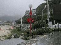


Typhoon Prasang is set to make landfall along the coast of Zhejiang Province. The national authoriti
According to the Ministry of Natural Resources, the National Marine Forecast Center issued a yellow wave warning and a yellow storm surge warning at 8:00 AM on September 18, implementing the Marine Disaster Emergency Response Plan. The Central Meteorological Observatory also issued a forecast stating that Tropical Storm Prasang, the 14th typhoon of the year, is moving rapidly.

The center of Typhoon Prasang was located over the northwest Pacific Ocean, approximately 630 kilometers southeast of Naha City in the Ryukyu Islands, at 5:00 a.m. on the 18th. The typhoon is forecast to move northwestward at a speed of 35-40 kilometers per hour while gradually intensifying. It is expected to enter the eastern part of the East China Sea on the evening of the 18th and make landfall along the coast of Zhejiang Province between the afternoon and evening of the 19th.
The National Marine Forecast Center anticipates that from noon on September 18 to noon on September 19, the East China Sea will experience huge to violent waves of 4 to 6 meters due to the influence of Tropical Storm Prasang. Near the coasts of Shanghai and Zhejiang, moderate to high waves of 2 to 3 meters are expected, with a yellow wave warning in effect. In the northern South China Sea, influenced by a tropical depression, huge waves of 2.5 to 4.5 meters are forecast, while the eastern and southern coastal waters of Hainan will also see moderate to high waves.

Additionally, storm surge warnings indicate that coastal areas from Nantong, Jiangsu to Hangzhou Bay will experience a storm surge of 50 to 100 centimeters on the 19th. Coastal regions of Ningbo and Wenzhou are expected to see a surge of 20 to 50 centimeters, with a yellow storm surge warning in effect for some areas.