


Hangzhou Meteorological Observatory issues a blue warning for a typhoon.
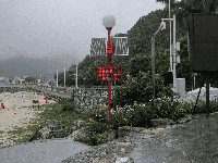
Hangzhou, September 19, 2024—The Hangzhou Meteorological Observatory issued a blue typhoon warning this morning, advising residents to take precautionary measures. According to the latest meteorological information, Typhoon Prasang, the 14th typhoon of the year, is expected to make landfall along the coast from Xiangshan, Zhejiang to Pudong, Shanghai this afternoon or evening. At landfall, it will be a tropical storm or severe tropical storm, with winds reaching force 9 to 11 (23 to 30 meters per second).

Typhoon Update
As of 11:00 AM today (the 19th), Typhoon Prasang was located approximately 465 kilometers southeast of Hangzhou over the East China Sea, at coordinates 29.1 degrees north latitude and 124.8 degrees east longitude. Maximum sustained winds near the center reached Category 10 (25 meters per second), with a minimum central pressure of 985 hPa. Prasingh is forecast to rapidly move west-northwestward at 30-35 kilometers per hour, with its intensity gradually strengthening.
Impact and Early Warning
Typhoon Prasang is expected to make landfall along the coast from Xiangshan, Zhejiang to Pudong, Shanghai this evening to night. The primary impact period for the Hangzhou area will be from daytime on the 19th to the morning of the 20th. The Municipal Meteorological Observatory forecasts:
Precipitation Conditions: Moderate to heavy rain is expected across the city on the 19th. Heavy rain may occur in parts of Lin'an, Yuhang, Linping, the urban core, Xiaoshan, Qiantang, Fuyang, and Tonglu. Torrential rain is possible in localized areas of the Tianmu and Longmen mountain regions. On the 20th, western areas will be overcast with moderate to heavy rain in the morning, followed by showers in the afternoon and evening. Other areas will be partly cloudy to overcast with brief showers.
Wind Conditions: From daytime to nighttime on the 19th, the plains will experience maximum northwesterly winds of force 6 to 8. Winds in mountainous areas and over lakes and rivers may reach force 7 to 9, with isolated areas experiencing winds as strong as force 10. Winds will gradually weaken on the 20th.

Additional Information
Additionally, Typhoon Soulik formed this morning but has yet to significantly impact Hangzhou. The meteorological observatory stated that starting September 21, cold air activity will increase as the subtropical high weakens and retreats eastward. With warm and cold air masses confronting each other over East China, Hangzhou will experience multiple precipitation events and a significant temperature drop. Highs will fall below 30°C, with only 25°C expected on the 22nd and 23rd, bringing the anticipated cooler weather.
Prevention Tips
The meteorological department advises residents to take precautions, especially during heavy rainfall and strong winds preceding the typhoon's landfall. Monitor weather developments closely, minimize outdoor activities, and secure homes and facilities—particularly in low-lying areas and locations vulnerable to wind and rain. Stay updated with official weather bulletins, maintain contact with family members, and ensure personal safety.