


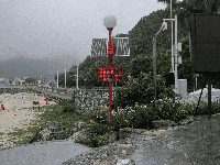


Typhoon Wan Yi and Cold Air Mass to Bring High Waves and Storm Surges to Waters off Zhejiang, Fujian
Due to the combined effects of a strong cold air mass and Typhoon Wan Yi (the 24th typhoon of the year), coastal waters off Zhejiang, Fujian, and Guangdong will experience severe sea conditions with high to very high waves, accompanied by significant storm surges. The National Oceanic Forecasting Center issued dual orange alerts for storm surges and waves today (the 18th).
Typhoon Wan Yi entered the central-eastern South China Sea on the night of the 17th. As of 8:00 a.m. today, the typhoon's center was located approximately 630 kilometers east-northeast of Sansha City, Hainan Province. It is forecast to continue moving west-northwestward to westward, maintaining or slightly intensifying in strength, and gradually approaching the eastern coast of Hainan Island. The typhoon is expected to rapidly weaken starting on the 19th.
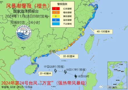
Regarding storm surges, from the morning of the 18th to the morning of the 19th, coastal areas from Hangzhou Bay to Zhangzhou, Fujian are expected to experience storm surges of 40 to 100 centimeters. Coastal areas from Chaozhou, Guangdong to the eastern coast of the Leizhou Peninsula will see surges of 30 to 80 centimeters. Coastal areas in northern and eastern Hainan Island will experience surges of 20 to 40 centimeters.
Regarding sea conditions, from noon on the 18th to noon on the 19th, the northern South China Sea is expected to experience violent waves to storm surges of 6 to 9 meters. The Taiwan Strait will see huge waves to violent waves of 4 to 6 meters. The southern Yellow Sea and East China Sea will encounter large waves to huge waves of 3 to 5.5 meters.